Straight roads
Turnpikes and
Land Enclosures
The enclosure of land was a capitalisation of the farming process. The Open Field system had been based on subsistence of ordinary people and mutual obigations between them and their land owners (like the Lord). Common land was usually owned, but had extended rights. The enclosing of fields was the creation or ordering of property, including taking account of Common Land rights. It served to improve agricultural output and technological development, and generate profit. Thus agriculture moved from feudalism to capitalism. Farming as enclosed was (along with slavery, and trade) a generator of a capital surplus that found its way into later industrial expansion. Yet the authorities decided to kill two birds with one stone, so that a side benefit of enclosing fields was an improvement in transport. After all there was little point in improving the land and its productivity, and its potential for specialisation, if its output could not be moved easily from the fields to market.
|
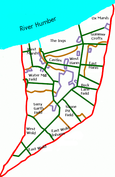
Field system and new roads
The yellow lines show old routes in between large fields (their old names in magenta). The green lines are new roads or roads put over the top of old local routes. They formed the skeleton around larger and smaller enclosed fields (not shown). Note that Street Road, the second crossroad from the south, is a very ancient pre-Roman regional route.
(Source: Russell, Russell, 1982, 55-56)
|
It's not often realised that the supply of better roads was an intended by-product of the Enclosure Acts. This was the case in the Barrow and New Holland area (then New Holland did not exist). Lincolnshire historically was a difficult place for transport. Roman Roads fell into disrepair and others flooded during the winter and were in a parlous state in summer, hardly providing anything like a smooth journey. Transport was possible by river, but obviously very slow. The decline in Lincolnshire as a centre for trade reduced the demand for good roads; this demand was only properly reversed by urbanisation and the need to take food to the masses.
At this time places were being joined up - regional and national transport made swifter - by the introduction of the turnpikes. The turnpike into northern Lincolnshire came in 1765. The introduction of new roads into Barrow with the enclosure of fields took place with an Act of Parliament in 1797 and was completed by 1803. This was late but not the last in the region (neighbouring Barton enclosed 1793-1796 and Goxhill, 1773-1775, but Thonrton Curtis to the south needed no Act of Parliament). This public scheme of enclosure made complete patches of old enclosures, particularly where Barrow-upon-Humber was and is (expanded) today. The Enclosure Acts and Turnpike Acts can be seen as one and the same intention in improving road transport.
In many places, like East Yorkshire, roads meander around fields. They connected farms, and today they have led to frustrating routes for motorists with many bends and lack of overall direction. However, in Lincolnshire, many roads were built and straight at the time of enclosure. The main road map around New Holland and outside Barrow was created by the 1797-1803 enclosure of fields. Many parishes of northern Lincolnshire were enclosed without an Act of Parliament; estates certainly would do the enclosing themselves, and "closed villages" saw their own speedier road improvements.
The Lord Yarborough of the time (based at Brocklesby) took a keen interest in the new turnpikes, reminding the Lincoln to Barton-on-Humber trust in 1826 to repair the roads to keep Lincolnshire up to the improving standard in the rest of England. The new roads locally made possible New Holland and preceded the introduction of a small ferry service (probably a cover for smuggling Holland gin), and furthermore facilitated the diversion of the stage coach from London to Barton (and so Hull) to New Holland (for Hull). Its ferry became viable and led on to the establishment of a railway connection in 1848 (when New Holland properly became a recognisable settlement). The Yarborough estate had influence in this part of northern Lincolnshire, and the name repeats itself all around (eg the Yarborough Hotel as was in New Holland for ferry travellers), but the estate only owned up to ten per cent of land in this area of northern Lincolnshire at its height - it was centred around Brocklesby with land owned around and in the Grimsby area. The Pelham family first bought land in 1564 and this became the Yarborough estate (1991 saw the eighth Earl) through purchases until after the First World War when land was sold. So there was only influence regarding the roads around Barrow/ new Holland as there was in the rest of Lincolnshire beyond the Brocklesby estate proper, where the roads are long and straight today too.
|
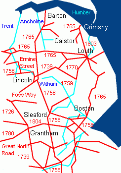
Toll Roads and Navigations
The toll roads and some of their dates are shown in red. River Navigations (improved rivers, even if primarily with drainage in mind) and canals are in blue. The stagecoach route came through Peterborough. The road off (not shown) that passes Barrow and ends at New Holland connected the re-routed stagecoach with the new ferry.
(Source: Bennett, 1999, 86) |
From the south the road to Barrow and New Holland was not a turnpike, but came from the one established in 1765 between Lincoln and Brigg with branches to Barton, Melton Ross and Caistor. This route came further from Peterborough. The Turnpikes facilitated longer distance travel for the enclosing profitable farms. They intended to allow higher profits through specialisation, the wider distribution of produce, and therefore higher rents. Actually the profitability of the turnpike to Barton was limited not just by the slump caused at the end of the Napoleonic Wars but also by the alternative of the River Ancholme ( a navigation that was improved principally for drainage reasons). In the late nineteenth century the struggling turnpikes were taken over by councils and the roads became free to use. The tradition of keeping toll bridges has continued until the present day, thus the Humber Bridge (opened in 1981) divided the doomed county of Humberside (formed in 1974) with its toll despite being intended to unite it.
Buses became frequent over the new reliable roads into the twentieth century. In 1913 Appleby's began in Conisholme (Louth) and grew across the county. In 1922 the Silver Queen Company was established in Lincoln, and was renamed the Lincolnshire Road Car Company in 1928. These two became the main providers of coach and bus services, the latter becoming the standard bus carrier when publically owned.
The bus service supplemented as well as provided competition with the railways. Humberlink was an East Yorkshire/ Lincolnshire Road Car Company pivotal link between Scunthorpe, Grimsby (the railway) and Hull (over the Humber Bridge) during Humberside's existence, and continues. However, now competition exists with a Hull, Sheffield and Grimsby service from Stagecoach, pivoting at Humberside Airport, and completely bypassing Barton (but stops at Brigg), undermining the bus and rail connection between Hull and Grimsby, and in part using the fast dual carriageways and motorways that provided more straight roads.
In New Holland, bus services have always been dwarfed by the railway. Even in the present day with only two hourly railway services, bus services are more minimal than in most nearby villages, and many use the two free buses provided by supermarkets (and not just for supermarket use either!).
|
Sources
|
| Russell, E., Russell, R. C., (1982), Landscape Changes in South Humberside: The Enclosures of Thirty-seven Parishes, Humberside Leisure Services |
| Bennett, S. (1999), A History of Lincolnshire, The Darwen County History Series, Chichester: Phillimore. |