Whilst the Humber estuary, at high tide, has provided a penetrating land route into the heart of northern England, it has also been a formidable barrier to communication north and south. Ferries were established from the Middle Ages, and in the nineteenth century the stage coach and then the railways (1832, 1845) moved the ferry from Barton to New Holland. However, the dream was always for a fixed crossing, being either bridge or a tunnel.
Each idea for a crossing was not rejected on grounds of practicality but existing interests and final plan and actual decision to build a Humber Bridge was based not on potential use but the political needs of a by-election and a marginal seat in Hull.
The conditions of the Railway Mania (1845-6) inevitably gave rise to suggestions for a railway crossing, but one main impetus for change was the monopoly position of the North Eastern Railway and its charging by tonnage not distance for transport, thus favouring ports further to the north east. Business people in Hull dreamed of access to the south, away from the NER, but this meant a scheme crossing the Humber usually to the Manchester, Sheffield and Lincolnshire Railway (which owned the ferry - being only a restricted access to the south bank system).
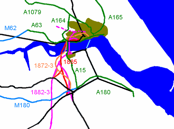
One such scheme was the Hull, Lancashire and Midland Counties Railway project in 1865 with a viaduct between Barton and Hessle (red on map). It did not get enough support from Hull business people nor the Manchester, Sheffield and Lincolnshire Railway.
A better supported scheme when the NER was even more despised was the 1872-3 Hull, South and West Junction Railway (orange on map). This involved a £340,000 tunnel between Barton and Hessle. A petition of 10,000 signatures was submitted to Parliament in 1873. After progress in the House of Commons, the NER scuppered the Bill though new opposition by the Manchester, Sheffield and Lincolnshire Railway in the House of Lords. This was because the NER granted it running powers over its lines into Hull.
The Hull and Barnsley Railway (1885) gave the Hull business people the outlet they needed to break the North Eastern Railway monopoly. Just before completion, a bridge from Barton to Hessle by the Hull and Lincoln Railway to the Hull and Barnsley Railway west of Hull, with a £532,000 bridge (pink on map), drew strong opposition from both the North Eastern Railway, the Manchester, Sheffield and Lincolnshire Railway and Goole shipowners ostensibly concerned about the effect of the multi-spanned bridge but probably worried about still better access from Hull.
Basically, the main railway companies both sides of the river still had an effective oligopoly, and by finding objections elsewhere they were able to frustrate the more ambitious schemes working against their interests. The oligopoly became a monopoly in 1921 with the formation of the London and North Eastern Railway which ran every railway around the Humber.
So in 1930 Sir Douglas Fox and Partners advised Hull Corporation that a practical and buildable road bridge would overcome the limitations of the ferry service.

One span would pass over the navigation channel and the rest would have shorter spans either side. Whilst river interests were overcome, the financial crisis severely affected the possibility of the scheme.
The location of Hull well east of national routes meant that the river crossing did not have national road planning priority then or for a long time. A bridge would be local. A Humber Bridge Act was successful in 1959 in allowing a toll paying bridge, but the south bank saw that its future growth with east-west traffic into the national road network had greater potential without a bridge.
However, the growth of regional planning, and the identification of the Humber north and south as one unit, in the Yorkshire and Humberside Economic Planning Council, meant that the Humber Bridge was seen as a means to unify both banks. A sort of industrial growth Tyneside was envisaged for Humberside, as it became known, with a 750,000 population town on the south bank (in the area up to where New Holland is).
The 1966 Hull North Parliamentary by-election proved a vital intervention. The Humber Bridge became a political carrot for the Labour Party in government when Barbara Castle said, "You shall have your bridge" (or words like it). Yet it was still not to be a trunk road but a local road, which meant hefty government and private loans with tolls to finance the repayment starting after 13 years with 60 years to pay. The construction began in 1972 but weather, strikes and the south bank foundations (concrete kept disappearing) meant that the opening was delayed by five years and the bridge finally opened in 1981. The engineering achievement and fine display of the then longest single span suspension bridge is set against its cost and use. The ferry instantly closed and the local railway became part of "Humberail" including the use of buses around Barton - a longer trip from Grimsby if more reliable.
The east west traffic on dual carriageways and motorways sidelines the Humber Bridge except for traffic between North East Lincolnshire and North Lincolnshire from as west as Scunthorpe. It is cheaper to go round from Lincoln and places west of Scunthorpe. Beverley is on the fringe of the economic use of the Humber Bridge. The maximised tolls are based on this reach. The bridge keeps shop prices higher and house prices lower in the south.
The new industrial town in the south never happened (ongoing economic crisis, a loss of confidence in planning), nor was there an emotional attachment within the new Humberside County from either side to the other. Humberside was seen as remote and lacked a history of a people, rather in the way that the European Union is criticised today. Eventually even this Conservative created council was scrapped in favour of not the old boundaries but local areas, as the Thatcher and post-Thatcher Conservatives claimed that local democracy should be simplified and unified, closer to people according to localities. The simplest solution of joining this area to Lincolnshire with local town councils was not pursued, so there is still a problem, if not so severe, of legitimacy.
The rise in traffic on the M1 and A1 has led to calls for an eastern motorway that would perhaps bypass Lincoln, come over the Humber Bridge and move on to the A19 and to Tyneside. This has come against the environmental and political argument against building more roads, although this itself is subject to the ebb and flow of congestion versus environment. It seems that eastern Lincolnshire, like northern Norfolk, is to be excluded from having decent roads.
So now the still lack of legitimacy in the south and the absence of an intention of unity leaves the bridge operating but without a clear function. It links itself to bypassing dual carriageways but is not really part of the national road system. It divides as much as it unites, rather like the ferry did. The debt mounted but was made more manageable with the new Labour government, but it continues. Traffic levels have risen as all traffic has risen, but the road is under-used.
The moment that tolls are removed the bridge will be transformed. It will be part of the national road network because it is a fast road alternative (it would create a need for a better road from the current dreadful Roman road from the M180 to Lincoln). The south bank will become a residential suburb of Hull as well as Scunthorpe and Grimsby, and development would take place between both banks. House prices will rise, ordinary prices (like petrol) will fall. Employment levels and the quality of employment in the south will rise. If the A46 to Lincoln is dualled and the A15 was also so transformed, there could be instant relief to the north-south congestion for some journeys, and Hull would certainly benefit as in mileage terms the journey via Lincoln's bypass south to London is shorter than swinging out west via the M62 and entering the north-south congestion early. This is even more the case with the M180 in the south, where the A15 provides a shorter and quicker route south but is woefully inadequate.
There is about an hour's difference in travelling to Heathrow Airport via Lincoln than on the M1 from New Holland. Journeys that even go slow on the A15 south of the M180 (often down to 40 mph with lorries on an undulating if straight narrow road) and then on the A46 travel have shorter journey times than traffic going via the M180's western limit and travelling to nearly the outskirts of Sheffield before going properly south. There is no justification on petrol or time going from the M180 and M18 down the A1.
Yet instead of this potential use of the bridge facility for north-south traffic, the trend is opposite, for example the movement of the University of Lincolnshire and Humberside to become simply the University of Lincoln. The stress is on east-west again, with this area often referred to as South Humber ("Humberside" being a dirty word with its emotional baggage), where economic units stretch between North Lincolnshire and North East Lincolnshire local authorities. The result is that the bridge is isolated, and no politician cares about it, unlike in 1966, and it becomes the price paid for having moved into cheaper housing if travelling to the north bank is carried out by locals.
North, J. A History of the Humber Crossing in Ellis, S. R., Crowther, D. R. (1990), Humber Perspectives, Hull University Press, 406-421.