When William the Conqueror took control of Britain he imposed his authority and system, eradicating the Anglo-Saxon social structure before it. There was a rebellion in the north assisted by Swein, King of Denmark, up the Humber, but William re-established control with "the Harrying of the North" which devastated the area to crush any chance of rebellions in the future. The Domesday Book, called because it was thorough enough for the last judgement, recorded much land of little value in 1086 north of the Humber.
William established power by handing out land to his loyalists. Drogo de la Beuvriere got land from William the Conquerer but he killed his wife and his land went to that Count of Aumale. This included Drogo de la Beuvriere's Castle in Barrow-on-Humber, as well as the one at Skipsea too which still has its 46 foot high motte (it was destroyed when one Count of Aumale rebelled). So down the line in this period the . There may have been a ferry between Paull and Barrow to link them, and so a castle or more may have protected Barrow Haven.
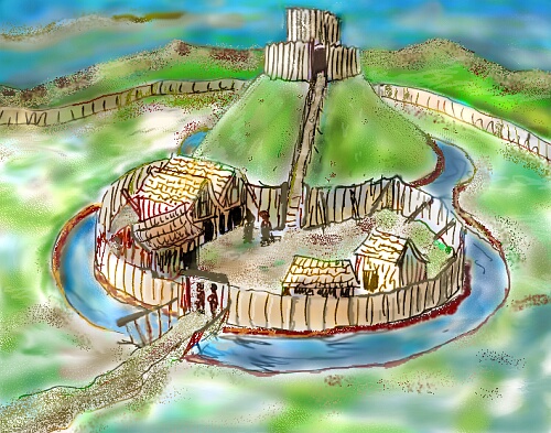
There is no trace of the castle or barrow itself in Barrow-on-Humber but then there was no building of stone castles in this area as it was peaceful.
The feudal system involved two hundred supreme "tenants in chief" being barons, bishops and abbots. They provided the Kings army or knights. Many knights has their own land. Lesser tenants received land for services. All landowners were Lords of the manor, who ruled with obligations over villeins. Each Lord of some substance had a Manor house where he lived on the first floor - the solar - and the vaulted ground floor was a store. There was an external staircase. The wrongly named Priory in Goxhill near Barrow (it looks like a religious building) was a good quality fourteenth century building with all the attributes of a good Manor House.
Remember then that New Holland had no separate entity from Barrow. It became part of Barrow Wapentake of the Yarborough lands.
At the time of William the Conquerer, Barton-on-Humber was the main port on the river. Nevertheless it declined from then on relative to Beverley and Hedon on the north bank as the wool and cloth trade expanded. Hedon and Grimsby declined, in favour of an island off Spurn called Ravenserodd, and by 1400 Hull was the third port in the country.
Material from:
Williams, A., Fairbank, J, of the Humberside County Council Archaeology Unit, Medieval Humberside 1066-1485, Archaeology Unit, Booklet 7, Humberside County Council Property Services Department for Humberside County Council Archaeology Unit and Manpower Services Commission, pp. 3-8
Adrian Worsfold's drawing base on an illustration in this booklet.