 The route through the Holme and Broughton areas is uncertain. This Jurassic ridge can be followed from the Mendips to the Humber and beyond and was a long distance route of prehistoric Britain.
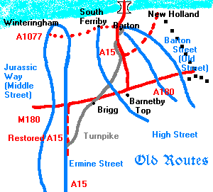
The local topography means that routes have come north and south, whilst east and west routes are poor. This is true even for New Holland, with no direct road to Barton, for example. The wider area has five ancient routes along which roads now pass.
In the west, the Jurassic Way (B 1398) follows the western rim of the limestone escarpment from Lincoln through Kirton-in-Lindsey (the Middle Street) to Winteringham and by trackway and parish boundaries between Manton, Hibaldstow and Scawby. The route through the Holme and Broughton areas is uncertain. This Jurassic ridge can be followed from the Mendips to the Humber and beyond and was a long distance route of prehistoric Britain.
High Street follows the chalk escarpment from South Ferriby cliff to Caistor and Horncastle. By the Humber it is known as "Middle Gate" and, given that "gate" is a Scandinavian word for "street" or "road", then it shows that the road was important for the Danes in the area in the ninth and tenth centuries.
The third route travels south east along the dip slope of the Wolds, as a trackway and continuous parish boundaries connecting South Ferriby, Yarborough Camp and Kirmington.
The Old Street runs north west though Ulceby, Thornton Curtis, Barrow-upon-Humber, and to Barton-upon-Humber. Its name throughout is Barton Street and stays above marsh level.
The most modern of these routes was Roman, now the A15 and then becomes the B1207 and finally unclassed as it reaches the Humber. It is Ermine Street, planned and executed during the first century C. E. by their military in limestone blocks approximately 13 to14 feet wide in a more or less straight line until near Winteringham at the low, clay ridge. Its line is approximately two miles east of the Jurassic Way along the dip-slope of the limestone ridge.
Used up to the Middle Ages the roads fell into disrepair. In 1765 a turnpike trust was formed and a road costing £80 to £120 a mile ran from Lincoln to Brigg and was extended in 1786 to Caistor. By 1791 coaches took 3 days to travel from London to Barton-on-Humber and Royal Mail coaches took this route from 1800. In 1836 the coaches were diverted to New Holland for the new ferry and coaches stopped going to to Barton after the railway to New Holland was built in 1848. By 1866 the Lincoln and Barton turnpike was no more.
The direct now B1206 road from Brigg to New Holland (B1218 continues to Barton midway) presently takes the lorry traffic to and from New Holland docks. It connects New Holland into the new box motorway and trunk road system. Whilst the A15 south of Scunthorpe continues to be an utterly slow, inadequate and dangerous (straight and undulating with hidden dips) single carriageway road (if with the Roman route restored to the M180 from its loss at the B1206 Kirton in Lindsey to Brigg), the box A15 is a fast dual carriageway to near motorway standard. It runs from near Barnetby Top over the Humber Bridge. The A180 and M180 passes near Barnetby Top providing the west-east route at about the latitute where the old east-west route formed (the A18). The A180 to the east goes past Immingham and into the north side of Grimsby, whereas the A18 went towards and then past beyond the south side of Grimsby.