|
We chose East Anglia for an area mum had not seen for decades (and then only in part) and for new views. Some of these were based on her and my art interest, particularly around the Suffolk coast and the area John Constable lived in and painted.
|
|
This meant we took some art materials to experience the area in a more fullsome way. The journey each day was planned the day before, except the first day which was planned earlier. This allowed mum to have a drawn map on her lap which I as the driver could see
|
|
Day 1 was the journey from home to Newton, north of Wisbech. Having obtained some provisions at Scunthorpe Morrisons, we travelled down the lethal A15 as far as the A631 roundabout where we turned off for the country route. This involved going via Market Rasen and (as it turned out) the national cycle route of the B1202. My first of many wrong turnings took me from Bardney to a small ruined abbey. We went via the Lincolnshire fields to the A15 where a wrongly numbered B road meant a missed turning of the B1429 so we went to the A 153 and B6403. It puzzles me why more is not made of roads like the B6403, as it bypasses Grantham and led to the A1. We took the A1 to the A606 and this allowed mum to see Rutland Water.
|
|
I had been there with Elena a year earlier and at that time we went to Hambleton and the lake edge that is inside the U shape of the lake. This time mum and I went to Whitwell, which was a little disappointing, and then we went via Oakham's left turning and Manton to the Normanton stop. It was quite cold there, and windy, and also it was not clear that the top level was not as interesting as going down to the lake side where the church jutting in was preserved. Indeed we went to a cafe higher up to find it was takeaway only into the cold when we could have gone to the lakeside cafe with a view and been inside. As it happened the car was taken lower down and we did a short walk towards the Normanton church. We could have done this from the beginning.
|
|
So the weather was cool or even cold, probably assisted that way by the water itself. Now we headed east and to the Fens. I like the Fens because of the perfectly flat landscape. There is a consequence of the drained land, however. As we came on to the B660 the road became very uneven. Many of the Fenland roads are sinking like this, produced cracked and uneven roads. We arrived at Ramsey (slightly raised up from surrounding land), which Elena and I had visited last year. This time, however, a chap was in the church, which meant mum and I could go in. He told us it was first built in 969 CE and was the hospitium to the abbey (the ruin nearby).
|
|
We moved on to find us directed down the unclassified road in the Chatteris direction, with a large dyke to the west and a chance of dropping into it. At Doddington on the old A141 I stopped to photograph one of these late Victorian clock towers (there is one in Warboys, one large one in Machynlleth - thus the interest) where a lorry thundered past us and nearly hit the car coming around the bend. We were parked safely enough but I suspect much rat running - after all the A141 is now redrawn bypassing all local centres.
|
|
We visited March (and another clock tower!) and then Wisbech became a nightmare of driving errors. It was an error when on the correct road going north on the A1101 that found the accommodation we had booked. Going to Gorefield from the B1166 rather than going to Newton from the B1165 we stumbled across the accommodation north of Gorefield whereas we might never have found it from arriving in Newton.
|
|
Four Winds was very well presented bed and breakfast accommodation, and the extras made the difference. It is two tied cottages combined into a large house. Mrs Best helpfully made extra drinks and offered to carry baggage; in the rooms though were all you could ask for regarding provisions, even fruit juices to add to the selection of drinks and means to make them. On top of this (and most important) the beds are not some hard frame and thin mattress, but full quality orthopaedic beds, and they made a difference to the sleep being both supportative and comfortable. So now I have this address I will ask to stay there when needing accommodation in the Fenlands to Cambridge area. The pricing is at the cheap end of bed and breakfast, and to be honest it was too cheap for the quality.
|
|
Day 2 was for the north Norfolk coast ending up at north Suffolk. We went via Tydd Gote (is Tydd related to the Welsh for farmhouse, Tyddyn I wonder) and Sutton Bridge. It swung as we arrived at the roundabout. It was an example of the utter inadequacy of roads into Norfolk, and a news item that evening on local BBC television had been about the chaos and over intensive use of the A14. Mrs Best had said that the M11 will come to Wisbech sometime, and that there will be a private railway line reopening to Wisbech. More on the M11 below.
|
|
I then became muddled at Kings Lynn, but decided on a change of route to nod at Sandringham. The estate reminded me of Scotland and the large parkland trees around royal estates there. It must be how they like it. After the nod we went to Hunstanton. This is a bit like Cleethorpes - seaside with a bit of river, in this case The Wash with views to Lincolnshire. We walked from Tesco through a car park and then funfair to the beach, and then I went to get the car so mum walked less. She was not impressed by the funfair. At least it was warmer than Rutland.
|
|
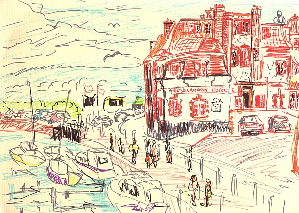
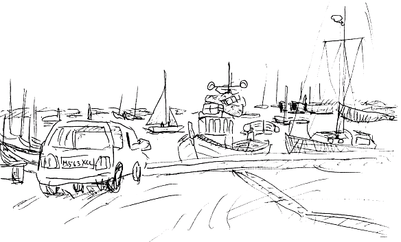
The north Norfok coast was impressive, served by a narrow twisty A road. We were caught in parking traffic on the side road at Brancaster and wondered if we could even get out. We paused at Wells-next-the-sea in a waterside cult de sac, and at Blakeney we were able to park and sat on chairs taken to do some sketching. The boats enjoy a natural harbour of built up silt; the Blakeney Hotel I sketched seems to have evolved with parts built on over time, and is very complex to sketch.
|